Hiking
Hit the trails
Part of what people love about Hendersonville and all of Western North Carolina is the scenic beauty of the rolling mountains and the our unparalleled access to get out and explore. Whether you are an experienced hiker or prefer a short walk to a scenic overlook, there are many hiking options to add to your itinerary. See below for options at all difficulty levels that are close to or in Hendersonville.
Biking
Leave No Trace
Scenic Drives
Insider Tips
Hiking Options
Notice: Bearwallow Mountain Trail is now open, however road closures in Gerton on 74-A and the lower section of Bearwallow Mountain Rd are still in effect. Hikers should only access the trailhead from the Edneyville side of Bearwallow Mt. The Hickory Nut Gorge is a very active Hurricane Helene recovery area. Be mindful that emergency response may be delayed due to road closures. Show your consideration and respect for the residents of this highly impacted area by respecting trail notices, staying off private property and only traveling on roads that are open to the public. You can find routes that avoid the road closures in Google Maps.
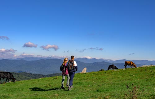
Located in eastern Henderson County at an elevation of 4,232 feet above sea level, Bearwallow Mountain is an easy to moderate one-mile (each way) trail that features a grassy meadow at its summit, which often has cows grazing, along with a historic fire tower, breathtaking scenery and a 360° view. From atop the peak, see such area landmarks as downtown Hendersonville, Mt. Pisgah, Mt. Mitchell, the Hickory Nut Gorge and upstate South Carolina. As of fall 2020, this trail now connects to the Wildcat Rock Trail at the mountain’s summit. Both the Bearwallow Mountain Trail and the Trombatore Trail start from the same parking lot, at 4854 Bearwallow Mountain Road, Hendersonville. Parking is limited, please only park in designated parking areas. Click on Conserving Carolina for additional information
Bell Park
**Open**
Bell Park offers 69 acres of tranquil forests on the edge of the Green River Gorge, with lush forests, waterfalls, and wildflowers including beautiful rhododendrons and mountain laurel. It extends from the High Bridge near Lake Summit, following the banks of the Green River, until it reaches the 14,000+ acre Green River Game Lands. Conserving Carolina acquired this land in 2015 and then worked with Henderson County to make it a public park. Bell Park was named in honor of summer camp pioneers Frank and Calla Bell and continues their legacy by creating a new place for people to connect with nature. Trail Length: 1.8 miles Difficulty: Moderate Great For: Running, Walking, Dog Walking.
DuPont State Recreational Forest
**Mostly open as of 1/2/25; a few trails still closed due to damage by Hurricane Helene or routine maintenance**
Encompasses 10,268 acres in Henderson and Transylvania counties. It is situated in the Little River valley and includes waterfalls and 80 miles of roads and trails wandering through mountainous terrain. DuPont State Recreational Forest is open to the public for hiking, mountain biking and horseback riding, with trails ranging from easy to strenuous in difficulty level. Popular trails include the Triple Falls and High Falls loop for hiking, and the Ridgeline Trail for biking, and the Cedar Rock Trail for both, however, you are encouraged to check out any of the park’s 68 trails, not just its most popular ones. Many scenes from the movie, The Hunger Games, were shot in DuPont State Recreational Forest. High Falls Access parking lot, 89 Buck Forest Rd, Cedar Mountain, NC — please note: parking is limited, please follow all signage. It is recommended you visit during weekdays, the off-season, and/or arrive early.
Holmes Educational State Forest
**Open**
Offers a series of well-marked trails, accented by exhibits and displays depicting the ecology of a managed forest. Most trails are rated easy, but the Demonstration Trail is rated as strenuous. Picnic sites with tables and a spacious picnic shelter (with grills) are also available. Holmes Educational State Forest is located about 8 1/2 miles from downtown Hendersonville. The forest hours vary by season. Located at 1299 Crab Creek Road, Hendersonville, NC.
North Carolina Arboretum
**Open**
Offers 434 acres of natural beauty, including 65 acres of cultivated gardens, and 10 miles of hiking and biking trails, which are rated easy to moderate and moderate to strenuous. There is a small fee to access the grounds. Located at 100 Frederick Law Olmsted Way, Asheville, NC, 28806. Visit the Arboretum’s website for a Hiking Guide.
North Mills River Recreation Area & Campground
**Open**
Part of Pisgah National Forest and located in Henderson County, just 13 miles from Downtown Hendersonville, the North Mills River Recreational Area has picnic sites, campsites, hiking, mountain biking trails, river fishing and is a great place to go tubing (bring your own tube). Trails range in difficulty level from easy to strenuous.
Oklawaha Greenway
**Open**
The Okalawaha Greenway stretches 3.25 miles, connecting Jackson Park, Patton Park, Berkley Park, Sullivan Park & William H. King Memorial Park. It is a relatively flat, paved trail runs along Mud Creek and is handicap accessible. This 10-foot-wide asphalt path is popular among both cyclists and pedestrians, is a great place to go birding and to look for wildflowers. Benches, water fountains, and three bicycle FixIt Stations are available along the trail. Parking is available at each of the connecting parks as well as in small lots on many of the intersecting roads.
Perry N. Rudnick Art and Nature Trail
**Open**
Located just outside Downtown Hendersonville, you will find multiple trails through both woods and meadows that are dotted with outdoor art. All trails are relatively flat and would be considered easy to navigate. Parking is available at the Kellogg Center and a small lot at 362 South Rugby Road in Hendersonville.
Pisgah National Forest
**Open in the Pisgah Ranger District**
Pisgah National Forest encompasses more than 500,000 acres of public lands, which are filled with waterfalls, countless miles of hiking and biking trails, rivers for fishing, swimming and tubing, waterfalls, scenic views, picnic sites, and camping sites. Some of the most popular hiking trails near Hendersonville include Moore Cove Falls (easy), Andy Cove Falls (easy), the Estatoe Trail (easy), Cradle of Forestry (easy), Pink Beds (moderate), Daniel Ridge (moderate), John Rock (difficult), Looking Glass Rock (difficult), Art Loeb (difficult) and many more. Check out Hike WNC for great hiking info or the Pisgah Ranger District Visitor Center, located at 1600 Pisgah Highway, Pisgah Forest, NC 28768.
Saluda Mountains Passage on the Palmetto Trail
**Open**
The Palmetto Trial is South Carolina’s very own state trail, which weaves its way from the South Carolina Upstate down to the low country of the coast, and this particular stretch of trail actually skirts the state line, winding its way through a good portion of Henderson County, between Tuxedo and Saluda, NC. This 9+ mile stretch is rated moderate to strenuous, and includes a lot of interesting and unique flora and fauna. Limited street parking is available on the side of the road on one end, on Anders Road in Zirconia, or at the Saluda end, parking is found at the Orchard Lake Campground.
Strawberry Gap Trail
**Open**
Built and maintained by Conserving Carolina (with the help of Southern Appalachian Highlands Conservancy and many generous landowners, donors and volunteers), the Strawberry Gap Trailhead is located in Gerton on Gerton Highway. The trail connects to the Trombatore Trail in the picturesque Blue Ridge Pastures after an approximately 2.8-mile hike, but sees about 800 feet in elevation change, making it a challenging hike. Please note, this trail is only open to human hikers, meaning no dogs, bikes or horses. The Starberry Gap Trail is part of the Hickory Nut Trail Gorge trail system, one of 12 North Carolina State Trails.
The Park at Flat Rock
**Open**
Situated on 66 flat acres, The Park at Flat Rock offers a 1.5-mile loop trail around the perimeter of the park, and many other shorter paths that criss-cross through the park, also totaling 1.5 miles. Many of the pathways are covered in fine-crushed rock, making them easy to navigate by foot, bike or with a stroller. The peaceful park has multiple ponds, many benches along the pathway, two popular playgrounds, a pavilion that can be rented out, and is home to many flowers and wildlife. The Park at Flat Rock is a great place to go for a stroll or to walk your dog. Open year-round from dawn to dusk and is located approximately 3 miles south of Downtown Hendersonville at 55 Highland Golf Dr., Flat Rock, NC 28731.
Trombatore Trail
**Open**
This strenuous 2.4 mile (each way) trail will get your heart pumping as it takes you through pastures up to a grassy bald with spectacular views of the Hickory Nut Gorge and Bearwallow Mountain. Both the Trombatore Trail and Bearwallow Mountain Trail start from the same parking lot, at 4854 Bearwallow Mountain Road, Hendersonville. Parking is limited, please only park in designated parking areas. Click on Conserving Carolina for additional information.
Blue Ridge Parkway
**As of 1/2/25; The sections near the Folk Art & Visitor Centers are open, but the section beyond The North Carolina Arboretum/NC Route 191 is still closed due to damage by Hurricane Helene or inclement weather; this stretch of the Parkway is typically closed during winter**
The “Nation’s Most Scenic Drive” follows the mountain ridges from Shenandoah National Park in Virginia to Great Smoky Mountains National Park in North Carolina and Tennessee, weaving along the north western border of Henderson County, a mere 15 miles north of Downtown Hendersonville. The Parkway’s 469 toll-free miles are filled with natural beauty, mountain forests, wildlife, wildflowers and magnificent views. There are numerous scenic overlooks, parking areas and more than 100 trails, ranging in difficulty level, but most are moderate to difficult. Much of the Blue Ridge Parkway, including the part closest to Hendersonville, is often closed during winter, due to poor driving conditions caused by wet weather and the higher altitude. It is always a good idea to visit the Parkway’s website for a list of Road Closures. For information, call 828-298-0398. The closest Parkway entrance to Downtown Hendersonville is the Bent Creek entrance, located at Parkway Mile 393 near the North Carolina Arboretum.
Carl Sandburg Home National Historic Site
**Partially Open as of 1/2/25 due to damage by Hurricane Helene; Please use Hiker’s Parking Lot**
Carl Sandburg, American poet, historian, author, and lecturer spent the final 22 years of his long and productive life at his estate, Connemara, in Flat Rock. Today this National Historic Site offers a keen insight into Mr. Sandburg, his family and their 264-acre working farm. The Sandburg Home houses his collection of 10,000 books, notes and papers. Home tours are offered daily tours. There are numerous hiking trails and a functional goat barn, where Mrs. Sandburg raised her prize-winning goats. There are five miles of hiking trails located on the Connemara property that range from is easy to moderate in difficulty level, with Glassy Trail being steep in only one place. It takes is about 35 minutes at a steady walk to the top of Glassy. Located at 1800 Little River Road, Flat Rock, NC.
Please note: Due to the dam on the property’s lake breaking, the hike to reach the house and goat barn has notably increased. There is a shuttle available as well as a second parking area closer to the goat barn, please follow all signage.
Cane Creek Greenway
**Partially Open as of 1/2/25 due to damage by Hurricane Helene**
This popular, easy walking path is partially paved and partially covered in fine gravel. It currently links to walking paths at Bill Moore Community Park, but there are plans for expansion. The Greenway runs next to and offers access to Cane Creek, which is a great place to fish or wade. Much of the Greenway is wooded, making it is a great place to, walk, run or bike. Ample parking is available at Bill Moore Community Park, located at 85 Howard Gap Road, Fletcher, NC.
Chimney Rock at Chimney Rock State Park
**Closed as of 1/2/25 due to damage by Hurricane Helene**
This popular attraction combines the best of the mountains with 75-mile panoramic views, unique biodiversity, six hiking trails ranging from kid-friendly to strenuous, and one of the tallest waterfalls on the East Coast. A unique 26-story elevator inside the mountain is an easy way to access the observation deck. The Park has been a filming location for many movies including “The Last of the Mohicans.” Located 18 miles east of Hendersonville. Check web site for hours and fees. Click for details.
Florence Nature Preserve
**Closed as of 1/2/25 due to damage by Hurricane Helene**
Located on the side of Little Pisgah Mountain, the tallest peak in Henderson County, this 600-acre property has 5+ miles of trails. The property was donated to Conserving Carolina and turned into public land in the late 1990s. Conserving Carolina is in the process of extending the trails on the preserve, to connect the nearby Wildcat Rock, Bearwallow Mountain, Trombatore, Strawberry Gap and Blue Ridge Pastures trails, forming one 20-mile-loop trail. These trails here are classified in difficulty as moderate to strenuous and include scenic views, creeks and cascades, wildlife, wildflowers and an old home site. Parking for the Florence Nature Preserve is located on Hwy. 74-A, at 3836 Gerton Hwy, Gerton, NC 28735, and is shared with the Wildcat Rock Trail.
Green River Game Lands
**Closed as of 1/2/25 due to damage by Hurricane Helene**
With more than 14,000 acres spanning Henderson and Polk Counties, and located southeast of downtown Hendersonville, this area is home to steep, rugged terrain and dense forest land, as well as access to the Green River, which offers both gentle and extremely difficult sections with class IV & V rapids — difficult even for expert kayakers. The Game Lands are managed by the North Carolina Wildlife Resources Commission and are used for hunting, fishing, hiking, mountain biking, and tubing or kayaking. Due to the difficult terrain, all visitors are urged to use extreme caution in all parts of the forest. Much of the Green River Game Lands are recommended for advanced hikers and expert kayakers. Parking is available at many locations, but some of the closest designated parking to Hendersonville and hiking trails would be on Big Hungry Road at the Bishop Branch and Pulliam Creek Trailheads.
Mountains To Sea Trail
**Partially Open as of 1/2/25; Some parts of the trail closed because the Blue Ridge Parkway is closed**
The Mountains to Sea Trail (MST) is the state’s official hiking trail. It covers 1,175 miles, from Great Smoky Mountains National Park in Western North Carolina to the Outer Banks in Eastern North Carolina. On its western-most end, it connects with the Appalachian Trail. The trail is split into sections, and the sections closest to Hendersonville include Sections 2 & 3.
Section 2: The Balsams — This stretch of trail, which begins far to the west of us and ends at the Pisgah Inn on the Blue Ridge Parkway, is rated “Strenuous” due to its significant elevation changes with steep climbs and descents, difficult trail tread, and long stretches without road crossings. This section includes the third highest peak on the entire trail, Waterrock Knob, which is at 6,292 feet in elevation. This section passes near some of the most popular parts of this section of the Blue Ridge Parkway, including Richland Balsam, Wildcat Falls, Devil’s Courthouse, Black Balsam Knob, Sam Knob, Graveyard Fields and Graveuard Fields Falls, Skinny Dip Falls, and more.
Section 3: The High Peaks & Asheville — This stretch of trail, which “begins” at the Pisgah Inn on the Blue Ridge Parkway, is rated “Strenuous” due to its significant elevation changes with steep climbs and descents, and difficult trail tread. The portions of Section 3 that are closest to Hendersonville primarily stay near the Blue Ridge Parkway and go through the Bent Creek area, and pass by the Blue Ridge Parkway Welcome Center and Southern Highland Craft Guild Folk Art Center. This stretch ends to the north east of Hendersonville, in Black Mountain.
Wildcat Rock Trail
**Closed as of 1/2/25 due to damage by Hurricane Helene**
This moderate to very strenuous 5-mile (each way) hike takes you to the summit of Bearwallow Mountain the long way around. Along the trail, you will see Little Bearwallow Falls, Wildcat Rock (which offers stunning views) and a picturesque ridgeline meadow. The most strenuous section of this hike is the portion between the waterfall and the ridgeline meadow. The trailhead is located on Hwy. 74-A, at 3823 Gerton Hwy in Gerton, NC, in eastern Henderson County, with parking available across the road at the Florence Nature Preserve. Trail maintained by Conserving Carolina.


